
Andy and I were always going to do different things today.
Well, originally, we weren’t. The idea was to do the Tongariro Alpine Crossing – one of New Zealand’s great walks and rated as the best one day walk in the World. ‘Towering mountains, turquoise lakes, sparkling rivers, lush rainforests and lunar landscapes. […] awe-inspiring mountain backdrop’ (quoted from Flying Kiwi’s itinerary).
Unsurprisingly, the night before we got the news that the crossing wasn’t going to happen. Too windy up there – wind speeds of up to 100km/h were forecast for the highest parts. Unsafe. Andy was very disappointed; he’s been looking forward to it. Following our walk to and from Cathedral Cove, Andy had made the call. I wouldn’t be walking the Tongariro Alpine Crossing; my knee was too sore.
There was an alternative day walk on offer and Andy signed up for it.
Him


5:00 alarm – it was still very dark and cold. Quick shower, got my stuff together and put on all the clothes I had. Grabbed some breakfast then boarded the bus for the 40 minute drive to Whakapapa where the walk started.
We were given a map but our walk was only about 2cm long on it so not too helpful. The paths are very well marked and maintained so a map wasn’t really necessary.
The sun was still just below the horizon when we started; the highest peaks just catching the first rays. To start with, the walk climbed gently across some lava fields; some low cloud on the horizon was keeping the sun from us.
After a couple of miles we crossed over a small ridge and there was the wind. Any jackets that had been undone were soon zipped up again. The path carried on for a few more miles over gently undulating ground then started to climb more steeply as we got to the first of the two lakes we were aiming for.
Lower Tama Lake is a brilliant blue colour reflecting the sky. It’s a volcanic crater lake, surrounded by the remains of the crater and some scree slopes.
The hardest part of the walk came next, a steeper climb to the Upper Lake. At one point the wind suddenly got stronger, two people were blown off their feet, no harm done. The upper lake is much darker than the first, nestling between steep scree slopes with mist and cloud hanging around the peaks above it.
The return walk was mainly in sunshine; the landscape looked quite different. For the last hour, we took a different route to see Taranaki Falls – an impressive 20m cascade and then walked back along the river valley to Whakapapa.
There’s one café in the town, their garden tables were the perfect place to enjoy a flat white and sit down for a bit. It was hard work at times but overall a very enjoyable 11 miles.
Her

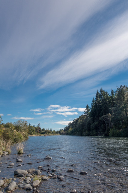


I heard Andy get up, and I heard him leave the house. I didn’t think I’d go back to sleep but clearly I did. I woke up around 8:45 (ooops). After breakfast and after checking out of the house, I borrowed a bike and went off to cycle the Tongoriro River Trail. I was given a map of the trail, but I didn’t quite get the instructions on how to get to the trail… so that was interesting. But I got to the river, and had a wonderful time. I made a number of stops to look at the river – there are many cool names on the trail such as Breakfast Pool and Never Fail Pool. Sadly, I had to be back at camp before 12.30, so I didn’t have time to go as far as Silly Pool. The trail was flat, a little hilly, a little gravelly and sometimes muddy. On my way back, I made a few more stops, and got chatting to a man who was inspecting the Major Jones swing bridge. It is inspected once a month. I joked that I should let him finish his inspection before crossing the bridge. Funnily enough, he found that one of the cables was too loose.
Back at camp, I had my lunch on a pallet converted into a swings and soon enough, it was time to go and get the others.
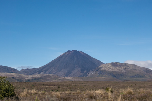
About forty minutes drive away, through some absolutely out of this world scenery, we met up with Andy and the rest of the group in Whakapapa Village, on the slopes of Mt Ruapehu. Simon had chosen to drive the slower but scenic route to the meeting point, and I’m grateful to him for that. We had amazing views of Mt Tongariro, Mt Ngauruhoe and Mt Ruapehu.
Him and Her – back together


After forty mins or so, we stopped in Taihape. We had just over 20 mins. We walked down to the main street and I popped into the i-SITE and got a town walk leaflet. We had enough time to see nine of the town’s sixteen highlights. Two of the most memorable ones – the Court House which was built around 1906, probably ‘spurred by the frequent unruly keg parties held in local paddock and the King’s (Majestic) Theatre which first screened films on Sunday nights from 1913. Taihape is also the Gumboot town. Remember Dargaville’s the kumara capital of New Zealand? Well Taihape is all about gumboots. There is a massive gumboot at the entrance of town. Just a little earlier, we’d passed Ohakune… and that town is all about carrots. Here’s what Lonely Planet has to say about it: ‘Expect to see carrots crop up all over Ohakune, for this is indisputably the country’s carrot capital. Carrots were first grown in the area during the 1920s by Chinese settlers, who cleared the land by hand and explosives. Today the venerable vegetable is celebrated during the annual Carrot Festival, and immortalised in a roadside tribute – the impossible-to-miss Big Carrot, erected in 1984′.
An hour or so later, we crossed the town of Bull. Now, they have a thing going on there. All town shops, restaurants and establishments have ‘bull’ in their names such as a deli advertising the fact that they sell ‘delect-a-bull’ food, or the police station where you can find ‘const-a-bull’. No kidding.
Dinner was fish and chips on Paraparaumu beach. We’d placed the order from the bus and we collected this huge box full of fish, chips, vegetable rolls, potato fritters, donuts and pineapple rings. The perfect food to re-fuel the walkers. A nice breezy walk on the beach after dinner and onwards to Paekakariki where we’re spending the night.
If I hadn’t been to Iceland I’d really struggle to take in the enormity of what you are experiencing. A valley the size of Singapore. Please keep your amazing blog going, this is amazing!
Thanks Chris. When we do get to see something, it’s always pretty near amazing.
We’re having fun writing the blog, and it’s definitely helping us to focus our thoughts and memories.
So why is Taihape the Gumboot town? Do they have a factory making them? I can understand the carrot one.
Well, the sweet potato and the carrot had gone. So in 1985, local businesses devised an annual Gumboot Day to make the most of their rural image. That’s what Wikipedia says. The rest, as they say, is history.
“Originally commissioned by Gumboot Country Promotions, which is no longer in existence, the gumboot is now maintained by the Rangitikei District Council.” More on this here.
Apparently the gum is used to make French polish too
Well, well, well… you learn new things every day.